Site Map
Favorite Hikes of author of this website:
- Oat Hill / Table Rock / Palasades. My favorite hike is to Table Rock for a little R&R, Picnic and Vino!
- Archer Taylor Reserve.
Favorite Local - Napa "exercise" Hikes: All located close to Town of Napa
- Alston Park (Dog Friendly) - Free - (Dry Creek Road near Redwood Road)
- Westwood Hills Park (Great Views of City of Napa) - Free - Browns Valley Road (Extension of First Street)
- Skyline Wilderness Park - Cross between Hiking / Exercise / Biking etc ($5 Car - 4 People & $1 extra per person)
Hiking Reminders and Etiquette: Be respectful to the land, water, vegetation and property. Do not trespass on anyone's private property; do not harm property, trails and vegetation.
I hope you enjoy the site. Keep on Hiking!
Below Hiking Areas - Site Map below travels from North (Calistoga) to South (Napa)
Stevenson Memorial Trail - Click Here A five-mile long trail in Robert Louis Stevenson State Park leads to the top of Mount St. Helena, but gives hikers the option of a two-mile round trip to the Stevenson Memorial before it continues up to the summit over fairly rugged terrain. The climb through oak, madrone, California bay and knobcone pine ultimately yields one of the best views of Napa Valley and, on a clear day, of the Sierra Nevada range and the San Francisco Bay. The trail description at www.parks.ca.gov confirms that winter is the best season to experience this breathtaking view, but expect to experience a bit of a chill as well. The trailhead, on Highway 29, is north of Calistoga, 8.2 miles from the junction with Highway 128. |
 |
|||||||||||||||||||||||
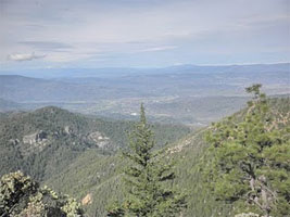
Oat Hill Mine Trail - Table Rock - Palasades - Click Here The old Oat Hill Mine wagon road starts at the edge of Calistoga and climbs for 4.8 miles, through a geological and biological smorgasbord, before descending to Aetna Springs. Hikers will find a moderate climb with spectacular views of the valley, Palisades, and Sugarloaf mountain. To hike all the way to Aetna Springs, a second car is recommended to shuttle back to Calistoga. However, this trail has enough to offer - alternating thick forest canopy with wide vistas of grasslands, vineyards and chaparral all the way up to the Palisades and beyond - to make even a partial trek worthwhile. |
 |
|||||||||||||||||||||||
| Another option is to continue on the Palisades Trail to Table Rock and Highway 29, where it's also useful to have a second car for transport back to the crossroads of Highway 29 and Silverado Trail. | ||||||||||||||||||||||||
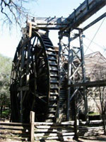
Bale Grist Mill - Click Here The park is the site of a water-powered grist mill that was built in 1846. It was once the center of social activity as Napa Valley settlers gathered to have their corn and wheat ground into meal or flour. The owner of the mill was Dr. Edward Turner Bale. He received the property in a land grant from the Mexican government and lived near the site until his death in 1849. The mill remained in use until the early 1900s. |
 |
|||||||||||||||||||||||
Bothe-Napa Valley State Park - Click Here 3801 North Saint Helena Highway (Hwy 29) |
 |
|||||||||||||||||||||||
| This park, near the northwestern corner of Napa Valley, tends to have more rain than the eastern regions of the county - all the better to bask in the rich riparian woodland and evergreen forest, and to inhale the enchanting aroma of California bay laurel in the wet season. For information on the 8.5 miles of trails in the park, visit www.parks.ca.gov. | ||||||||||||||||||||||||
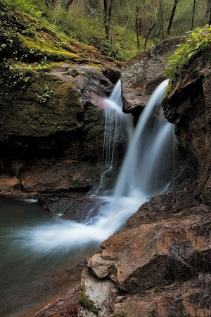
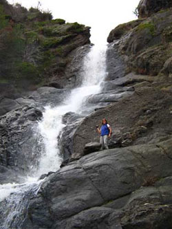
Devils Punchbowl Falls - Click Here Angwin, Napa County. Devils Punchbowl Falls is a very scenic little 14 ft. high waterfall dropping into a gorgeous little gorge and pool. UPDATE: 6/12/15 TRAIL CLOSED I had received an email from the facilities manager of St. Helena hospital which owns the property that the trail to the falls are located on. The property owner clearly states the property is private and trespassers will be prosecuted. Upon request, I have removed the street address and trail descriptions. |
 |
|||||||||||||||||||||||
Zim Zim Falls - Knoxville Road - Lake Berryessa - Click Here The trail along Zim Zim Creek provided nice, easy hiking, but be prepared to wade across the creek many times. Depending upon the flow in the creek it may be possible to keep your feet dry if your hiking boots are waterproof. Alternatively you may want to go barefoot across the creek or wear shoes that you don't mind getting totally wet. |
 |
|||||||||||||||||||||||
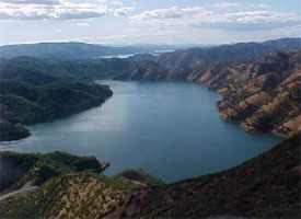
| Lake Berryessa - Click Here Summer is not hiking season, but in the mornings, or if the weather is clement, there are trails to be hiked. Location: approximately 32 miles from Downtown Napa Directions: take Silverado Trail to CA-121 N/Monticello Rd, turn left at CA-128 W/Capell Valley Rd, turn right at Berryessa Knoxville Rd/Knoxville Rd, slight left, turn right, turn right. Smittle Creek Trail: This is a 2.6 mile easy trail along the shoreline between Smittle Creek Park and Oak Shores Park. North End Trail: This especially scenic trail winds along the north shore of Lake Berryessa. The trail is an easy one with limited elevation gain and wonderful views down the full length of the lake, some 10 miles away, and to the Blue Ridge to the east. Pope Canyon Trail: This scenic trail follows the original Pope Canyon Road roadbed for about one and a half miles until the roadbed disappears into the lake. Segments of the Blue Ridge Loop Trail: The full hike is a 4 mile loop hike up Cold Canyon, and then a climb up to and return along the Blue Ridge. This is a very strenuous hike. The Homestead Trail: This trail is on land that is part of the UC Davis Natural Reserve System, one of the few such reserves that allows public access. NO DOGS are allowed on this trail to protect the creek, plants, wildlife, and ongoing research projects. Up to Blue Ridge: This is a strenuous switchback trail from Cold Canyon up to the top of Blue Ridge. |
|
|||||||||||||||||||||||
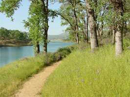
Napa River (Crossroads Yountville) - Click Here
|
 |
|||||||||||||||||||||||
Alston Park (Dog Friendly) - Click Here
|
 |
|||||||||||||||||||||||
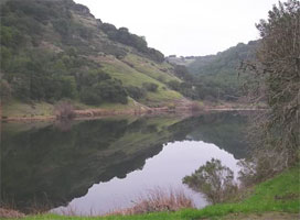
Archer Taylor Reserve - Click Here The 380 acre Archer - Taylor Preserve contains some of the oldest & largest stands of redwoods in the Napa County and the habitats range from redwood riparian to grassy meadows. It is the result of the extraordinary and exemplary generosity and foresight of the Taylor family. Preserve, located in Napa county, once owned by Taylor family, now is a protected area maintained by a non-profit organization Napa Land Trust. The trust organizes several hikes in this preserve every year. |
 |
|||||||||||||||||||||||
Westwood Hills Park - Click Here Trail Statistics & Information
|
 |
|||||||||||||||||||||||
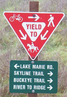
Skyline Wilderness Park - Click Here Within this 850 acres of treasured open space, a 5.8-mile loop trail of moderate difficulty climbs through grassy oak woodlands and chaparral. With limited cover and a potential for serious heat in the summer, the trail is a perfect candidate for winter hiking. A detailed guide to the Skyline Park trail, including native plants to be seen |
|
|||||||||||||||||||||||
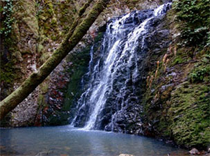
Mt. George Waterfall hike - Click Here Enjoy wildflowers in bloom on this Land Trust hike. View |
||||||||||||||||||||||||
| OTHER PLACES OF INTEREST: | ||||||||||||||||||||||||
| Oxbow Preserve Restoration Project Location: City of Napa - The entrance to the park is from McKenzie Drive just off the Silverado Trail. There is a gate to the park that leads to the parking area that has 8 parking spaces. Dogs are allowed currently on leash per our municipal code. Hours: The park and parking area are open at sunrise and closed at sunset each day. Distance: 12.7 acres of green in the oxbow of the Napa River across the river from Copia. Grade: Easy |
||||||||||||||||||||||||
| Kennedy Park Trail Directions: On Streblow Drive off Soscol Avenue, just south of the Napa Valley College Distance: 7/8 mile one way Grade: Easy |
||||||||||||||||||||||||
| Rooster’s Ridge Fish and Game managed land with future trail extension to Stag’s Leap Location: In the Howell Mountains east of Yountville Directions: From Trancas Street in Napa the trailhead is 8.7 miles north on Silverado Trail, just south of the county of Napa, Yountville Maintenance Facility Distance: ½ mile+ Grade: Moderate |
||||||||||||||||||||||||
| Lake Hennessey Excellent lakeside winter birding at Napa’s municipal reservoir Location: Conn Valley east of St. Helena Directions: From St. Helena take Pope Street, Howell Mountain and Conn Valley Road to the Lake. Distance 4 miles roundtrip Grade: Easy |
||||||||||||||||||||||||
Public's right to access to public waterways and rivers: California Law relating to the public's right to use rivers for recreational use CA Codes (gov:66478.1-66478.14) 66478.3. The Legislature further finds and declares that it is essential to the health and well-being of all citizens of this state that public access to public natural resources be increased. It is the intent of the Legislature to increase public access to public natural resources. CA Codes (gov:25660-25662) 25660. On the application of any person interested, the board of supervisors may by ordinance declare all or any portion of any slough, river, or stream to be a public highway for the purpose of fishing therein, if it: 25661. If any owner of land adjacent to or across which the slough, river, or stream declared to be a highway for fishing flows does not consent to its use for such purpose with the right to pass along the banks for the purpose of fishing and on application refuses to grant the right of passage to the county by suitable instrument in writing, the board may contract for and purchase any such rights. 25662. If the right of passage cannot be purchased at a satisfactory price, the board may authorize condemnation proceedings to be commenced to procure the right. |
||||||||||||||||||||||||