| |
|
- Location & Directions: Zim Zim Falls – Knoxville Lake Berryessa
- Berryessa to Knoxville Road
- Turn right at the 128/121 intersection, staying on 128.
- At the Turtle Rock bar, turn right again onto Berryessa/Knoxville road.
- Continue on Berryessa/Knoxville, past the lake, over both Pope Creek and Putah Creek bridges at the North end of the lake, and up into the mountains beyond.
- The road will narrow, roughen, and you will wind up until you reach the public lands.
- There are several concrete low-water crossings.
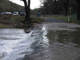
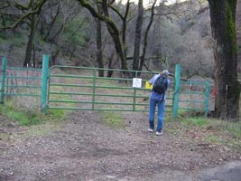
- Parking is available across from the green gate, just before a creek crossing, just before mile marker 24. If you see mile marker 24, you've gone about 100-feet too far.
- Trail Distance: Approximately 7- 8 miles in and out. Alternate Route ~ 11 mile loop
- Level of Difficulty: Easy with incline up to the falls
- Elevation Change: Approximately 400′ total elevation change
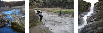
- Children: Grass and Dirt Path – There will be 18 creek crossings – You will get wet
- Dogs: Dogs Allowed – Leashed and Clean Up
- Cost: Free
- Be sure to check weather (sufficient apparel); bring water; allow travel time
- Hike is within a 12,575-acre addition to the Knoxville Ranch State Wildlife Area
- N 38.75197 W 122.28337 - Zim Zim Falls trailhead (A).
N 38.78092 W 122.31864 - Zim Zim Falls (B).
N 38.76151 W 122.31289 - Overlook to Lake Berryessa (C)
|
| Berryessa Knoxville Road The last bathroom is 18 miles (mile marker 18) down Berryessa Knoxville Rd. on the right side at Eticuera Creek day use area. You may want to make a quick stop here. The trailhead is a few more miles down Berryessa Knoxville Road. |
|
|
| Continue on Berryessa/Knoxville, past the lake, over both Pope Creek and Putah Creek bridges at the North end of the lake, and up into the mountains beyond. The road will narrow, roughen, and you will wind up until you reach the public lands. There are several concrete low-water crossings. Parking is available across from the green gate, just before a creek crossing, just before mile marker 24. If you see mile marker 24, you've gone about 100-feet too far. See Image on Right. |
|
|
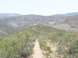
| Pass through the green gate (above), hiking back along the dirt road which follows Zim Zim creek. A few routes will spur off, heading back into the hills. Stay in the valley, heading up the canyon along the creek |
|
|
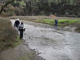
| There are 8 or 9 creek crossings on the way, so you will get wet. When you get near the end of the valley, you will see a pink-colored boulder in the road, at a fork in the trail. Stay right, heading uphill. You will come to another fork shortly thereafter, and head left on that one. |
|
|
| |
|
|
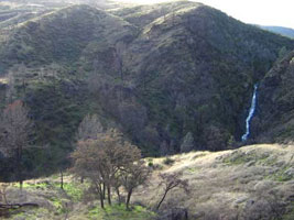
| The route will then lead you back to a view of the falls. |
|
|
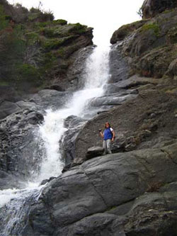
| Alternately, you can just head straight up the creek once you get to the intersection with the boulder, and view the falls from below. More cross-country if you do this route. |
|
Hiking the Trail to Zim Zim Falls and Beyond.
The trail along Zim Zim Creek provided nice, easy hiking, but be prepared to wade across the creek many times. Depending upon the flow in the creek it may be possible to keep your feet dry if your hiking boots are waterproof. Alternatively you may want to go barefoot across the creek or wear shoes that you don't mind getting totally wet.
The Hike:
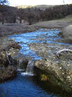
Pass through the green gate, hiking back along the dirt road which follows Zim Zim creek. A few routes will spur off, heading back into the hills. Stay in the valley, heading up the canyon along the creek. There are 8 or 9 creek crossings on the way, so you will get wet. When you get near the end of the valley, you will see a pink-colored boulder in the road, at a fork in the trail. Stay right, heading uphill. You will come to another fork shortly thereafter, and head left on that one. The route will then lead you back to a view of the falls. Alternately, you can just head straight up the creek once you get to the intersection with the boulder, and view the falls from below. More cross-country if you do this route.
Distance: The entire hike is about 7-8 miles, out and back to and from the falls.
Alternately, you can make a longer, 11 mile loop if you go past the falls, follow the trail behind the falls and cross the creek south into the Nevada Creek drainage. This loops around the mountain range separating Nevada Creek and Zim Zim Creek. Be sure to take the correct trail to complete the loop at the southern part of the loop at Nevada Creek. The map shows that you have to take the eastern trail at the south end of the loop. There are numerous trails that branch off from the hike route.If you continue too far down Nevada Creek, you end up on private property. The GPS track will guide you if you have a GPS unit.
You can also do a shorter 9.5 miles if you hike the ridge west of Zim Zim creek and then cut back to Zim Zim creek. Get to the ridge by hiking the trail behind the falls and then south as if you were going into the Nevada Creek drainage. At the top of a saddle between Zim Zim Creek and Nevada Creek, take the eastern route up to the ridge. The map shows the longer loop as well as the ridgetop hike with the cutoff to Zim Zim creek. There are lots of other trails that aren't shown, since I haven't taken them yet.
How to get there:
From Yolo County, take Highway 128 toward Lake Berryessa. Turn right at the 128/121 intersection, staying on 128. At the Turtle Rock bar, turn right again onto Berryessa/Knoxville road. Continue on Berryessa/Knoxville, past the lake, over both Pope Creek and Putah Creek bridges at the North end of the lake, and up into the mountains beyond. The road will narrow, roughen, and you will wind up until you reach the public lands. There are several concrete low-water crossings. Parking is available across from the green gate, just before a creek crossing, just before mile marker 24. If you see mile marker 24, you've gone about 100-feet too far. I have an image of the parking area below.
This hike is within a 12,575-acre addition to the Knoxville Ranch State Wildlife Area, which closed escrow on December 15, 2005
Additional Stats from other web sources:
- Duration: 3 hours (NOT including drive time) Distance: 7.5 miles (RT)
- Elevation: 700 ft. (-500 ft.)
- Lat/Long: 38.78066N, 122.31867W
- Height of Waterfall: 80 Ft Difficulty:
- Easy Things to wear: waterproof boots/sandals & long pants
- Trail Information Zim Zim Falls Topo Map Directions: Take 80 West, exit 70 to merge onto CA-113 N toward Woodland, exit 29 for Covell Blvd. toward Road 31, Turn Left at W Covell Blvd., continue on County Road 31, slight Left at County Road 93A, slight Right at Russell Blvd., continue on CA-128 toward Lake Berryessa. Turn right at the 128/121 intersection, staying on 128. At the Turtle Rock bar, turn right again onto Berryessa/Knoxville road. Continue on Berryessa/Knoxville, past the lake, over both Pope Creek and Putah Creek bridges at the North end of the lake, and up into the mountains beyond. The road will narrow, roughen, and you will wind up until you reach the public lands.
- There are several concrete low-water crossings.
- Parking is available across from the green gate, just before a creek crossing, just before mile marker 24. If you see mile marker 24, you've gone about 100-feet too far.
- This hike is within a 12,575-acre addition to the Knoxville Ranch State Wildlife Area.
- Description: The trail to Zim Zim Falls follows an old road along Zim Zim Creek. It is mostly flat the whole distance, with great scenery along the way of the lovely creek, rolling green hills, pretty wildflowers, and plenty of oak trees.
- The total distance hiked is about 7.5 miles there and back.
- The trail crosses Zim Zim Creek a total of 9 times along the way, and you will get your feet wet.
- It is easy crossing the creek, the deepest it will get is up to your shins. I do recommend wearing shoes that you can get wet, so you're not constantly taking your boots off and on every 10 or 15 minutes on the hike.
- Shortly after the last crossing, you will come to a trail junction (a big boulder is on the side of the trail here).
- Go right and up the hill (the trail becomes quite a bit steeper here, but not too bad).
- At a second junction, go left. The trail cuts back to a great viewpoint of Zim Zim Falls.
- It is possible to scramble down to the base of the falls. But it is steep and you will need good footwear to do that. Zim Zim Falls cascades down about 80 ft. through a narrow cleft in the canyon.
- I suspect that it may actually be higher than 80 ft., and there is an upper part of the falls that is not visible. It is definitely a waterfall that is best seen in the winter and early spring months.
- By summer, Zim Zim Creek will only be a trickle
|
|
|