
Lake District / Lake Berryessa
The Lake District
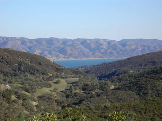
An overview of trails in Napa County wouldn’t be complete without including the eastern region of the county, especially Lake Berryessa. For those willing to endure a beautiful drive on Napa’s backroads — past blue oaks dripping with lace lichen, valley oaks dangling mistletoe, and buckeye leafing out in response to winter rains — a variety of trails can be found about 45 minutes from Napa. One popular trail along the shoreline of Lake Berryessa is Smittle Creek, a 2.6 mile, easy walk to Oak Shores Park.
During winter and spring months, the lake is quiet, the coves and nearby islands are green, and raptors, including bald eagles, are frequently spotted. Further north along the Knoxville-Berryessa road, just beyond Putah Creek Bridge, a trailhead on the lake side of the road enters the North End Trail. In anticipation of major realignment to make it more sustainable, the trail is not currently being maintained and can become narrow in places. Yet it still affords a scenic walk along the lakeshore, where western grebes and osprey are quite common. More information on these trails, the Pope Canyon Trail and the Stebbins Cold Canyon Trail just below Monticello Dam
Smittle Creek Hike: 2.6 mile, easy walk to Oak Shores Park.
- Length/Degree of Difficulty: easy to moderate shoreline hike, modest elevation gains along the way.
- Trail Condition: well marked and maintained with a good trailbed.
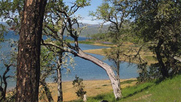
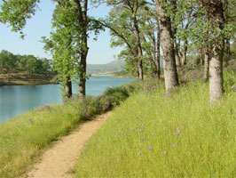
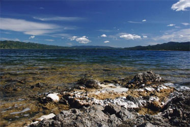
Smittle Creek Trail. This is a 2.6 mile easy trail along the shoreline between Smittle Creek Park and Oak Shores Park. It’s a cozy hike, meaning the islands are not far offshore and it winds in and out of small coves. There are places to stop for a picnic, shoreline fishing, and a swim.
This trail provides a fairly easy hike along Lake Berryessa's shoreline from Smittle Creek Park to Coyote Knolls in Oak Shores Park. Just offshore can be seen Big Island and Small Island. Spring is the best time; winter is good too. Summer is the time to bring a swimsuit for a dip in a quiet cove. As you wind along the shore, look for the Bald Eagle nest high in a tree on Big Island. This is an active breeding nest and Bald Eagles are frequently seen along the trail. You might also spot dear in the park.
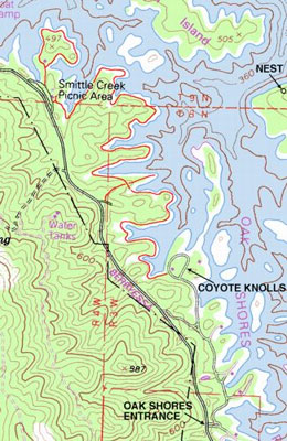
The northern trailhead begins at the southern end of the Smittle Creek parking lot, located about a mile north of the Oak Shores entrance. Take the steps down the hill to the bulletin board which has a map of the trail and is the trailhead. The trail starts to the south of the bulletin board (to the right if you are facing the board). The southern trailhead is at Coyote Knolls, the northern-most parking lot in Oak Shores Park, now included in the new temporary campground. The trailhead is by the bulletin board which has a map of the trail.
Although not formally part of the Smittle Creek Trail, another short trail begins at the northern end of the parking lot. Follow the trail to the restroom where the trail continues to the left. This loop trail offers great views up and across the lake.
Smittle Creek Nature Trail (.7 mi). The first .7 miles of the Smittle Creek Trail is a nature trail, with a brochure and numbered stations to stop and ponder nature. From why downed trees are not removed (that’s habitat!), to the beneficial relationship between fungus and algae that produces Lace lichen (an indicator of clean air) and why Manzanita leaves rotate, the brochure for this self-guided trail will leave you enthralled. You can continue on to Oak Shores Park, or make a loop back to the parking lot.
The Stebbins Cold Canyon Trail is just below Monticello Dam
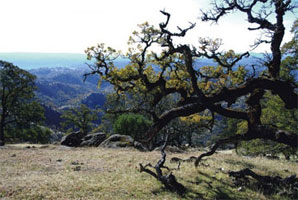
View of the narrows of Lake Berryessa from the Blue Ridge portion of the Loop Trail (Rt Image)
The full hike is a 4 mile loop hike up Cold Canyon and then to the Blue Ridge with spectacular views of Lake Berryessa and the surrounding area. Alternate partial hikes are a half mile (one way) very steep hike to the Spillway Overlook on the ridge or a moderate one mile hike (one way) up the canyon to the Old Homestead.
Length/Degree of Difficulty:
- Loop trail - 4 miles, strenuous, elevation gain of 1500 feet
- Canyon hike to old homestead - 1 mile (one way), moderate, elevation gain of 520 feet (No dogs as it's a nature reserve).
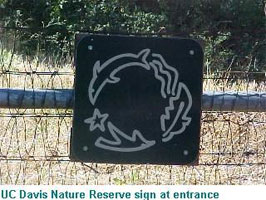
- Ridge hike to Putah Creek valley vista - half mile (one way), very strenuous, elevation gain of 1040 feet. (If you have a dog with you, skip the Canyon portion. Pass the entrance sign shown below and continue on the road until you see a second silver gate on the left. Head up to the top of the ridge here, and then south once you reach the top. Come back the same way).
Trail Condition: maintained, traihead well marked but otherwise unmarked, trailbed obvious, footing rough along ridge.
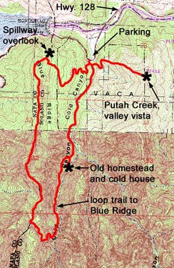
Part of this hike is in the UC Davis Nature Reserve and part is on BLM land. See links below for information on wildflowers, plants, wildlife and the old homestead ruins. The trail map is courtesy of Yolohiker.org
Follow these driving directions to the trailhead. A short distance up the trail from the road is a bulletin board with a detailed map and, usually, brochures describing interesting features along the walk to the Old Homestead.
Napa - take Trancas east towards Lake Berryessa. It becomes Monticello Road, also known as Highway 121. Stay on this road as it becomes Highway 128 (without turning), and continue on past Monticello dam. On a curve you will pass two silver gates on the right - the second gate with the UC Davis logo is the entrance. Past the entrance will be a large dirt pullout on the left where you can park.
Napa Co. up- and mid-valley - from Silverado Trail, take Highway 128 past Lake Hennessy. At the junction with Highway 121, stay on 128 which will entail a left hand turn. Continue on past Monticello dam. On a curve you will pass two silver gates on the right - the second gate with the UC Davis logo is the entrance. Past the entrance will be a large dirt pullout on the left where you can park
 |
 |
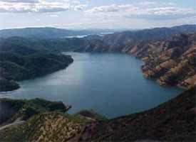
Lake Berryessa
North End Trail. This especially scenic trail winds along the north shore of Lake Berryessa. The trail is an easy one with limited elevation gain and wonderful views down the full length of the lake, some 10 miles away, and to the Blue Ridge to the east. With luck, you may see White Pelicans, Golden and Bald Eagles and the more common Western Grebes and Osprey.
This trail was constructed by the Youth Conservation Corps in the late 1970’s. Originally it had a series of split log bridges, which unfortunately deteriorated over time and had to be removed. The lack of bridges is no barrier to hiking the trail as they covered fairly shallow drainages which are currently dry.
However, there is a plan to realign the trail to a more environmentally sustainable route, away from wetlands and eroding areas. Consequently, the trail is not currently being maintained and can become faint in places where the grass has taken over. However! One cannot get lost on a trail so close to the lakeshore.
There is a series of trailheads along the road and the trail is often used by anglers for access to the shoreline. It is also a great place to find a quiet cove for picnicking and swimming. A couple of close coves can be found by accessing the trail from the Putah Creek trailhead and walking north. If you are looking for a place to launch a kayak, the Putah Creek trailhead is closest for heading up the creek, although it is a bit of a walk down to the lakeshore. La Pointe trailhead, a couple of miles down Berryessa-Knoxville Road, also leads to some quiet coves down a rather steep hill.
The Barton Hill and Gibson Flat trailheads lead to a short loop trail. Schoolhouse Cove trailhead has short and easy access to the water and can be a good place to put in a kayak or canoe. Buckhorn and Blue Monday trailheads also lead to quiet coves. Racoon Lagoon trailhead leads to an interesting creek canyon with the trail winding to the east along a steep creek bank. Light rains over the last few winters, however, mean the creek canyon is relatively dry right now.
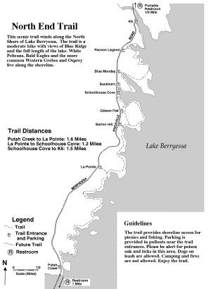
Click Here for Larger Printable PDF
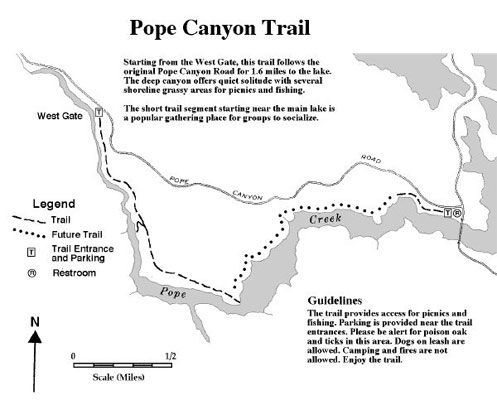
Pope Canyon Trail.
- 1 1/2 Miles
- Degree of Difficulty: Easy and wide.
- Trail Condition: wide old road, good trailbed, footing somewhat rough in spots.
Field on point at end of old road
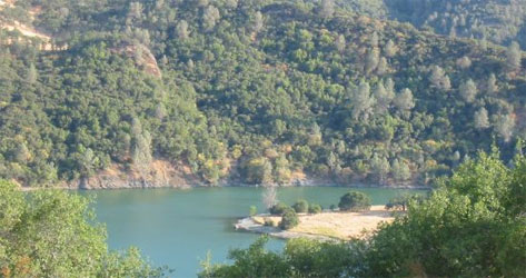
This scenic trail follows the original Pope Canyon Road roadbed for about one and a half miles until the roadbed disappears into the lake. The trailhead is a couple of miles west along Pope Canyon Road from the Knoxville Road intersection. Look for a sturdy brown and yellow striped gate on the south side of the road. Small hiker signs on a post and on the gate announce the trailhead.
From the gate, the trail heads down and to the left and then follows the old road towards the main lake. Below the trail is first Pope Creek and further along the Pope Canyon arm of the lake. After about 3/4 of a mile, an old jeep trail cuts sharply to the right from the main roadbed and descends to a nice grassy shoreline that is good for a picnic.
The trail passes through fencelines which denote the boundary between Bureau of Reclamation and Bureau of Land Management property, both of which are open to the public.At the end of the old road are large fields overlooking the water and scenic rock outcroppings (see photo above).
Swim and picnic here under large Oaks, being careful of rattlesnakes when walking off trail in the tall grass. Western Grebes and Osprey are often seen in this idyllic spot.
Cedar Roughs Trail
Looking down Pope Canyon at Lake Berryessa and Blue Ridge
The Cedar Roughs Trail provides access to the Cedar Roughs which encompasses the high ridge on the west side of Lake Berryessa. Views from the ridge are extraordinary and include the lake, Blue Ridge and Chiles and Pope Valleys. The trail now goes along the north end of the ridge to a scenic overlook and is under constant improvement and and will eventually extend to the top of the ridge.
The trail begins at an old rusty white gate on Pope Canyon Road. From the brown and yellow gate at the trailhead of the Pope Canyon Trail, proceed about 0.1 miles west (away from the lake) on Pope Canyon Road to the next turnout on the left. The turnout is a few feet east of the "Napa 06.75" mileage marker. Park at the gate or in a larger pullout across the road. The trail begins at the rusty white gate at this turnout. The gate is marked with a somewhat obscure hiker sign. Go to the left on an old roadbed which makes a broad curve to the right. Follow the trail up Pope Creek through a switchback and upstream across rocks about 100 yards where the trail is visible across the creek going up through a wide opening in the trees. If you reach a sign labelled "Private Land Beyond This Point", backtrack about 100 yards.
Cross the creek at this point by following a rope line and wading the creek. Use extreme caution wading if the water flow is high or consider abandoning the hike. Crossing Pope Creek during the rainy season is often impossible and remains a boot filling experience until, usually, some time in May. Ascend the trail to an old carriage/jeep road. Turn left and follow the road uphill.
After about a 1/2 mile climb, the trail passes through a broad meadow. Take the right fork where the path splits in the meadow. The path then descends briefly down a canyon on the far side of the meadow and continues a short distance along an old road cut before turning sharply right and beginning the climb into the Cedar Roughs. Follow the cairn line for another mile along the ridge to a point where the trail turns right and ends on a scenic rocky overlook.
A four page brochure entitiled "Cedar Roughs" with more information about the Cedar Roughs and the first seqment of the Trail, including a map, is available from the Bureau of Land Management (BLM). It is highly recommended that hikers obtain this brochure before hiking into the Roughs. To request a copy online, go to the BLM Ukiah Map Request Page. The written description and the map from the brochure are also available online from the BLM site.
*Degree of Difficulty: Moderate climb. Length is two miles with 800 ft. elevation gain.
*Trail Condition: maintained and marked; follows an old road to the meadow and a cairn line to the overlook.
Lake Berryessa Wildlife Area
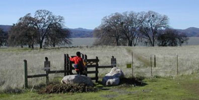
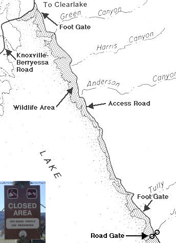
The east shore of Lake Berryessa is an undeveloped wildlife area backed by cattle ranches. The well maintained gravel East Shore Ranch and Fire Acess Road allows public access for almost six miles of the shoreline starting from the Knoxville-Berryessa Road and extending south to a turn-around loop. The area between the road and the water is the Lake Berryessa Wildlife Area. The road provides public access to the Wildlife Area as well as ranch and fire access. The Wildlife Area extends south from the end of the gravel road to the dam and is accessible by foot.
There are two pedestrian access gates through the fence that runs on the lake side of the road. The first gate (labeled E1) is 0.2 miles from the Knoxville-Berryessa Road and allows access to the northern end of the Wildlife Area. Parking is available across the gravel road and a short distance to the north of the gate. The second gate (labeled E14 - see photo above) is 5.5 miles from the Knoxville-Berryessa Road and allows access to the middle of the Wildlife Area. Short trails lead from each gate to the shore. A large variety of raptors and water fowl may be viewed from the trails including White Pelicans, Golden and Bald Eagles, Western Grebes, Cormorants and many species of ducks.
While the entire Wildlife Area is open to hikers and bird watchers, visitors should be aware that rattlesnakes inhabit the tall grass and thistle that cover much of the area.
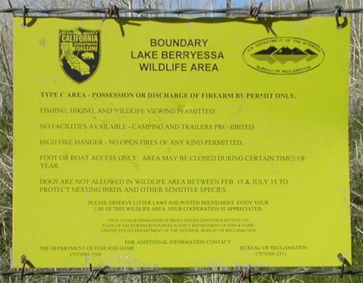
Signs posted on the fences (see below) give regulations governing the Wildlife Area. There are 15 numbered metal gates (labeled E1 to E15) along the public access road. Hikers may climb over any of these gates to access the Wildlife Area.
Note that the somewhat confusing "Closed Area" signs (see photo below) mean only that the area behind the sign is closed to off-road vehicle use. Unless otherwise noted, foot access is allowed and hikers are welcome.
All of the land to the east (away from the lake) side of the road is private property and not open to the public. The ranch houses are not appropriate sources of information, water or bathroom facilities; contact the ranchers only in case of a real emergency.
*Degree of Difficulty: Easy shoreline hikes.
Quail Ridge Reserve Summer and Fall
