Oat Hill Mine Trail / Table Rock Trail / Palisades
Napa Valley High
Table with a View
Celebrate the region's wild side with three big-view hikes and under-the-radar wineries.
Hike, sniff, swirl, and sip. Repeat as needed.
Some of the most outstanding hiking in the Bay Area is on the Palisades and Oat Hill Mine trails near Calistoga.
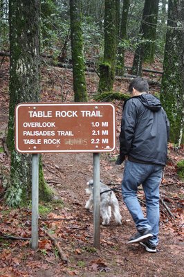
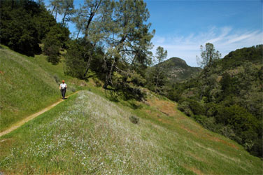
Table Rock Trail (3 miles, moderate difficulty) winds though forests and chaparral to a scenic overlook. It connects to Palisades Trail (four miles, moderately strenuous), which connects to Oat Hill Mine Road (4.5 miles, moderate). Hikers also can access Oat Hill Mine Road from a trailhead at Highway 29 and Silverado Trail in Calistoga.
Both the 3-mile and 11-mile hikes will start at the Table Rock Trailhead in Robert Louis Stevenson State Park - Park on East Side (off Highway 29).
The five-mile hike will be an out-and-back to Table Rock, rated moderate, returning to the trailhead. The 11-mile hike, rated strenuous, will be a thru-hike ending at the Oat Hill Trailhead, which is one mile east of Calistoga.
Both of these hikes will take you through forest, open chaparral, and along volcanic cliffs. Wildflowers -- such as California poppies, lupine, fiddleneck, and monkey flower -- should be in their prime around April.
HIKING MAPS - PDF
Table Rock Trail to Table Rock Overlook
 |
 |
 |
 |
 |
 |
Table Rock Trail climbs steadily through a forest of manzanita and pine with occasional views of the south peak of Mt. St. Helena to the north. After about half an hour you will came to a rocky outcrop with fine views northeast over Middletown and the surrounding area.
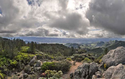
A few spots along the afforded excellent views south and east, way out toward Point Reyes. After a short bit we came to a plateau signed "Table Rock Outlook". We went onward, soon coming to a bunch of volcanic rocks with excellent vistas south over all of Napa Valley. This is a great place to have a sandwich and wine.
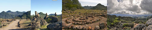
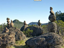
We espeied a bunch of tall rock stacks in a valley a short ways below us; since that's where our trail appeared to go anyways, we went thataway. A short and slippery descent brought us to a flat area that had quite a number of very tall man-made "ducks" (stacks of rocks, often used to mark faint trails, but purely decorative here).
We had excellent views of the Palisades to the south, continue onwards for another 3/4 mile or so, on a narrow and sometimes rocky trail, and you will arrive at Table Rock itself - it's a flat outcrop on the north end of the Palisades cliffs, and an excellent lunch destination). There was a neat spiral of rocks, and the trail was lined as well - somebody (or bodies) had spent quite some time here arranging the rocks.
It seemed appropriate to contribute our own modest rock stack, so we did, finding it fairly difficult to assemble rocks in a tall configuration without undue interference from gravity.
I've long wanted to hike the Palisades Trail and this hike just increased that desire! The area is ripe with natural beauty, both the nearby jagged landscapes of the Palisades, and the long-reaching views of the ocean, Napa Valley, Mount Diablo, etc. We agreed that come spring, we must do the entire Palisades Trail when wildflowers are afoot. Our little hike to (near) Table Rock was a great bang for the buck and is definitely recommended if you only have a couple of hours.
Hike Stats:
Distance: |
~ 5 mi |
Total Time: |
1h 45m |
Elevation Gain: |
~900'? |
Difficulty: |
5 |
Scenery: |
9 - beautiful! |
Trail condition/markings/etc: |
6 - only so-so markings |
Overall rating: |
8 |
Long Hike - Table Rock to Palasades Ending - Oat Hill Mine Road:
- (> 10 Miles) - Requires two cars or someone to drop you off
- Start: Tailhead at the summit of Highway 28 on Mt. St. Helena.
- End: Calistoga at Oat Hill Mine Road (Near Corner of Hwy 29 / Silverado Trail in Calistoga)
- Hike Time: ~ 7 Hours (Recommend Leaving 8am but no later than 10am)
There were few flowers initially since we were in dense forest, but we soon came to some patches of Milk Maids, Miner's Lettuce, Indian Warrior, Paintbrush, and Shooting Stars, along with the ubiquitous Poiso Oak and a very lost-looking bush of lavender. At a rocky outcrop near the trailhead, we had lovely views to the northeast of a snow-capped mountain range (during winter).
Climbing, then descending through a rocky wash, we arrived at the clearing where there were many rock "ducks" (rocks stacked on top of each other in sometimes precarious arrangements), and a nice rock spiral.
From here on we hiked on new territory and soon realized that our previous hike on this trail did not take us particularly near Table Rock at all. Our trail descended through a seeping hillside rife with Monkeyflower and Broad-leaf Filaree, then climbed fairly steeply and over rather rocky terrain for nearly a mile, and the going was slow. Nearing the top of an obvious ridge, we followed a creek and soon came to a lovely grotto bursting with wildflowers, and then, arrived at Table Rock.
Table Rock is a flat rocky feature on the very north edge of the Palisades, a craggy set of cliffs on the northeast side of Napa Valley (prominently visible from downtown Calistoga).
We left Table Rock, continuing now on the Palisades Trail, which descended at a fair grade. The Palisades Trail is only a couple of years old, and is set somewhat edgily just below its namesake cliffs. Vistas were fairly jaw-dropping all around, but we had to pay a good bit of attention to the trail itself, as it was narrow, rocky and steep. In addition to the flowers already seen, we saw patches of Shooting Stars and Mission Bells. About an half an hour after leaving Table Rock, we came to Lasky Point (2,040').
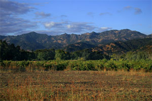
Here a comemorative plaque paid homage to Mr. Lasky, who had a big hand in getting the Palisades Trail created, and we continued to have lovely views down the green oak-studded hills to the valley below with its geometric squares of grape fields. We soon continued on our way, climbing and descending along the base of the cliffs, still on a rather rocky and rough trail, but with just fantastic views.
Wildflowers became much more diverse here as the trail entered and left shady forests and open hillsides, with a long laundry list of species making a nice show of it. These included: Vetch, some fat succulents, Scarlet Pimpernel, Purple Clarkia, Blue Dicks, Paintbrush, Bush Lupine, a large-flowered shrub, Phacelia, Blow Wives, Baby Blue Eyes, Blue-eyed Mary, Cañon Delphinium, Purple Sanicle.
The trail here was mostly a gentle grade, but was side-sloped and still rocky. The constant right-facing slope on the trail was starting to take a toll on our ankles and we wished for a trail that sloped to the left for at least a short ways! We passed several waterfalls, one in particular of reasonable height, and blanketed with loads of flowers at its top. The trail steepened from here, climbing some stone steps (which we appreciated, as it would be very difficult going without them), then reaching the (unmarked) high point of the hike and turning downwards.
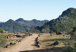
We descended on a steep goat path to the junction with the Oat Hill Mine Trail. There was a bit of crumbling building foundation here, presumably from the old mine that operated here early in the 1900's. Descending to the right on the Oat Hill Mine "Road", we still had about 4.5 miles to go, and were starting to get a little tired!
Oat Hill Mine Road was, as most old wagon roads are, a reasonable grade, and we continued to have excellent views of the cliffs of the Palisades to our north, Calistoga to our west, and wildflowers everywhere, including a new-to-us Kellog's Monkeyflower, a whole heck of a lot of Cañon Delphinium, easily the most I've seen in one spot, Fremont's Death Camas, Shepherd's Needle, White Hyacinth, the occasional Ground Iris, and Bearded Clover. In places we could plainly see the ruts cut by wagons as they carried whatever it is they mined here back to the valley.
Although it trends downward, it's by no means without climbing, and those with a fear of heights may take umbrage with the narrow trail, gingerly carved into the base of the cliffs. This hike is an epic, and absolutely beautiful, day.
Hike Stats:
Distance: |
10.5mi |
Total Time: |
7h 56min (incl. 55 min stopped at Table Rock and lunch) |
Elevation Gain: |
~1,700' |
Difficulty: |
8 - longish, rocky, steep and narrow |
Scenery: |
10 - stunning! |
Trail condition/markings/etc: |
5 - getting lost isn't likely, but it's somewhat tough going in places. Trekking poles are your friend here. |
Overall rating: |
9.5 |
The Palisade's trail has been called Calistoga's stairway to heaven. I don't know about that, but it is a freakin awesome hike out to Table Rock.
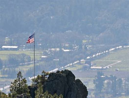
Having grown up in the area, I was accustomed to seeing these majestic rocky outcroppings up in the hills that hug the northern end of the Napa Valley.
But a few years ago, I went on my first hike out amongst these cliffy wonders. It's a moderate to strenuous hike, about 4.4 miles round trip. If you're in shape, then you'll have no problem! The views of the valley and all the vineyards, especially in fall when they are all glorious shades of orange, red and brown are spectacular and make sure to go to the far right once you arrive on the lava rocks and you will be rewarded with awesome, adrenaline pumping standing-on-the-edge-of-a-cliff delight!
It gets pretty warm up here, even on chilly days (maybe it's all the exertion) so wear layers.
Oh and bring some water and a snack. The last time I went I forgot to bring anything so I was without nourishment and hydration and felt very light headed towards the end of the trek, which was no bueno.
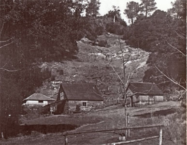
The Holms homestead was named after Karl Gustov Holm a Finnish settler in the late 1890's.
History:
Route Description
As previously stated, brief descriptions of the Table Rock trail and Oat Hill Mine Road are included since either must be traveled in order to reach the Palisades trail. The route will be described from west to east, moving along the Table Rock Trail to the Palisades trail and then descending down Oat Hill Mine Road. From the trailhead to Table Rock is 2.3 miles. The Palisades trail from Table Rock to Oat Hill Mine Road is 3.9 miles. Oat Hill Mine road from the junction with the Palisades trail to Calistoga is 4.8 miles. The entire trip is 11.0 miles long.Table Rock Trail
The trailhead for the Table Rock trail is located at Saint Helena Summit on Highway 29. The trailhead for Mount Saint Helena is located across the highway. The Table Rock trail climbs steadily up a ridge leading to the trail highpoint, known as the Turret. The forest canopy generally covers the route, but 0.25 miles from the trailhead there is a large outcrop that provides excellent views of Mount Saint Helena, Snow Mountain and the Clear Lake Basin (although Clear Lake itself can not be seen). From the turret, views of the Sierra Nevada and the Napa Valley are excellent. The trail then begins to descend into Garrett Creek Canyon. Near the bottom of the canyon, a telephone box marks the junction with the route to the base of Table Rock. Beyond the junction, the trail reaches and crosses Garrett Creek. It then begins to climb back out of the canyon, entering a gully that reaches all the way to the base of Table Rock. A sign marks the beginning of the Palisades trail. From here a short detour to the top of Table Rock is recommended. No trail leads across the moonscape summit, but the route is not difficult to follow.
Palisades Trail
From the junction of the Table Rock and Palisades trails, the route begins to climb up the flanks of the western Palisades highpoint. The climb is not difficult and in short order the route begins to descend along the south-facing ridge that connects the Palisades and Table Rock. The trail is extremely well engineered, the grade is very gradual and the construction is excellent. At the switchbacks, large rocks have been placed to create stairs. In spite of the great quality trail, its narrow gauge and thick mat of forest debris indicates how little use it receives.
After several switchbacks, the trail finally levels out and soon passes a marker indicating the boundary of Robert Louis Stevenson State Park. The Palisades trail is now on Lasky Family property. If one looks back, the southwest nose of Table Rock is visible and Mount Saint Helena looms in the distance. The trail soon rounds a shoulder and one is treated to the first views of the Palisades. The band of dark rock is seen undulating along the ridge top, with numerous spires and high cliffs. A monument at the vista bears a plaque thanking the family of Moses Lasky for the right-of-way across their land. It further describes how Lasky was a lifelong climber, who climbed the crags of the Palisades and even participated in pioneering a new route up Grand Teton in 1980.
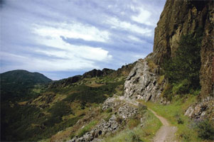
From Lasky Point, the trail begins its traverse of the first amphitheater, where it reenters Robert Louis Stevenson State Park. The vegetation alternated between typical California chaparral, oak savannah and dense glades of firs and hardwoods. At some points the trail passes right along the base of the Palisades cliffs. Numerous gullies lead up into the interior of the crags, providing access to the higher portions of the Palisades. At the east end of the first amphitheater, the route passes through a particularly thick glade watered by a small creek. It then rounds a shoulder and passes into the second amphitheater. Throughout the length of the trail, the route it slung precariously on steep slopes that drop away from the base of the Palisades.
Once in the second amphitheater, the cliffs of the Palisades get higher, sheerer and craggier. Nonetheless, the trail remains similar than when it passed through the first amphitheater. It is generally level, with small ascents and descents. Views down into the Napa Valley and Calistoga are excellent and Mount Saint Helena is often visible. This section of trail passes a few more small creeks. It should be noted that with the exception of Garrett Creek beneath Table Rock and the creek draining the third amphitheater are all seasonal and even the two aforementioned streams are quite small after spring.
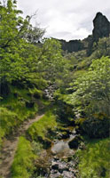
The wall forming the east end of the second amphitheater protrudes far out from the main band of cliffs. Consequently the trail passes further from the base of the cliffs. Views to the south are excellent here and Mount Saint Helena is particularly attractive. Soon the shoulder is rounded and the Palisades trail enters the third and final amphitheater. The east highpoint is visible and Duff lies just a short distance to the east. This area is further enhanced by the presence of a small waterfall formed by the main creek falls into a small grotto lined by volcanic rocks. When water levels are high the falls can be surprisingly large and two other ancillary falls also plunge into the grotto. This is one of the most scenic parts of the entire trip.
From the waterfall, the Palisades trail begins to climb. A ridge separating the western portion of the amphitheater from the slopes of Duff must be surmounted. To accomplish this, the trail passes through a short series of switchbacks, and then maintains a steady grade for about 0.25 miles. Shortly before the switchbacks commence, the route passes by a series of neat lava pinnacles. Once the trail reaches the top of the grade, it is directly beneath the final cliff section of the Palisades. The east highpoint lies atop the cliffs. The highpoint, though shorter than the western highpoint by 2 feet is the more attractive of the two, being an excellent example of columnar basalt.
Two high waterfalls are found along this section of trail. Both fall into small grottos with dense vegetation. They tend to fall away from the cliffs so that by the time they reach the ground, it resembles rain more than a waterfall. The second of the two falls is particularly nice, falling on a large flat rock ten feet above the trail. Climbing up onto the moss and fern covered rock and standing under falling water is an excellent treat this far into the trip. After the small waterfalls, the trail turns north and makes a swift descent down to Holm’s Place. Large hand-hewn stones form the ruins of the old homestead. The presence of a big stone hearth is particularly interesting. From the ruins, it is only a few yards further to the historic Oat Hill Mine Road. The road was constructed to access an old mine beyond the homestead. Wagon ruts worn into the volcanic stone are still visible in the upper sections of the trail. One must respects the men and beasts that traveled this road in the past.
Oat Hill Mine Road
The Napa Valley and Mt. Diablo from Oat Hill Mine Road
The upper portions of Oat Hill Mine Road pass along the western flanks of Duff, the peak that marks the eastern terminus of the Palisades. Beyond Duff, the ridgeline softens and there is little exposed stone like the crags that form the Palisades.
The views of the Palisades from this section of trail are magnificent. Saint Helena is seen towering in the distance. Soon, however, the trail turns eastward and passes along the southern ramparts of Duff. The entire length of the Napa Valley comes into view and Mt. Diablo is visible on the distant horizon. The view is amazing and remains constant for nearly a mile.
From the base of Duff, the route passes along the eastside of a large group of crags and then turns west again, passing beneath Bald Hill. This is the last view of the Palisades. Beyond Bald Hill, the views of Napa Valley persist for another 0.5 miles before the trail plunges into the forest.
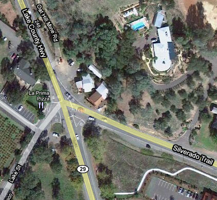
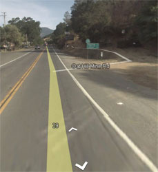
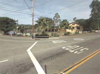
From this point on the views that have been constant throughout the entire trek are lost, save for an occasional clearing. A couple more miles deposits one at the Oat Hill Mine Road trailhead, right across the street from an excellent pizza parlor.
 Oat Hill Mine Road (Hwy 29 / Silverado Trail) For 11 Mile Hike from Table Rock / Palisades.. this is where you would come out at. |
 Silverado Trail / Lincoln / Hwy 29 (Calistoga) |
| |
|
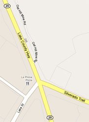 Oat Hill Mine -Silverado Trail / Lincoln / Hwy 29 |
 |
| |
|
 |
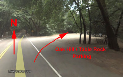 Oat Hill / Table Rock Parking |