
Robert Louis Stevenson State Park - Mount St. Helena
Mount Saint Helena is the highest point in the San Francisco Bay Area watershed
- Directions: Calistoga / Silverado Trail ~ 7-8 miles North of CA Hwy 29. Mile marker 49 is where the parking
is.
- You’ll see a sign for Robert Louis Stevenson State Park at 3801 Saint Helena Hwy, and there are parking areas on both sides of Highway 29.
- Park in the left-hand lot (West Side), which is closest to the trailhead.
- No bathrooms, No Camping.
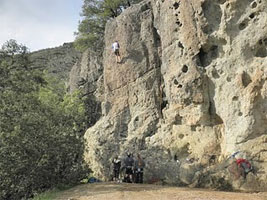
- At the bottom of the trail there are some nice picnic benches in a meadow. Also if you don't feel like hiking to the summit, there is a nice view about 2.5 miles up with a beautiful rock, people were climbing when we were there. At this spot there is a redwood bench/barrier.
- No admission fee
- Hikers!!! Mount St. Helen "hike" is mostly a Fire Road, however with great views at the end. If you are seeking hiking trails, I suggest you go across the road and hike Table Rock / Oat Hill Mine / Palisades trail for scenic hiking.
Mount St. Helena Hiking Trails. The Mt. St. Helena Trail starts your climb up the mountain about 300 feet west of the main parking area. The trail meanders at a gentle grade through forest for 3/4 mile to a stone monument, which marks the site where Robert Louis Stevenson spent his honeymoon in an abandoned mine building during the summer of 1880. From here, you climb more steeply and leave the forest to intersect the fire road. After a short walk, you can look down on the patchwork of the upper Napa Valley and beyond to Mount Diablo and Mount Tamalpais. As you continue on the south-facing slope of the mountain, you'll be surrounded by chaparral, and the higher up you go, the more exhilarating the view. At 3.6 miles, a road branches to the left leading to a ½-mile hike to the South Peak.
| To get to the Mt St Helena's Trail, you first must walk the Stevenson Memorial Trail a short, accessible trail with very generous switchbacks and,consequently, several points at which hikers had made short-cuts. | 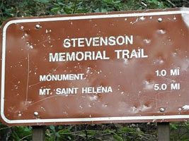 |
| After walking along this restful foresty, shaded trail, accompanied by the chuckling of a shaded brook, you reach this memorial, at the 0.8 miles mark, to Robert Louis Stevenson, the famous author who honeymooned in the area and actually wrote The Silvarado Squatters there. | 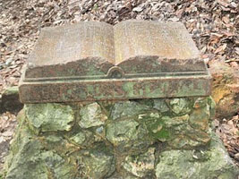 |
| After seeing the Stevenson Memorial, you scramble up some severely eroded trail: | 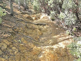 |
| And find, eventually, this sign, when you pop out in a relieved fashion on a fire road: | 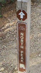 |
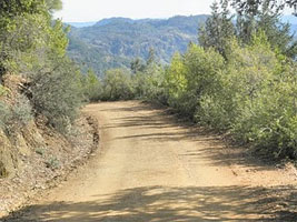
And you're ready to start up the hill. No more chuckling brooks, no more forested shade. Be prepared with plenty of water, block, and sunhats--the entire Mt St Helena's trail is actually a switch-backey fire road to allow the maintenance vehicles up to take care of the communications towers on top of the summmits. |
 |
| Plenty of stunning views on the way up | 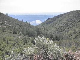 |
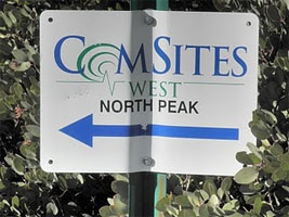
Summit has several communications towers on them and there are two earlier 'false summits' also full of communication towers. Be prepared then to pass two communication tower summits before you reach the actual North Peak. Once you see this sign, you're about 0.5 mile from the top. :) |
 |
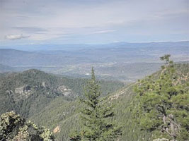
The views were tremendous. Look for Lake Berryessa, Napa, and Calistoga, and others. It's worth that final steep push to the end |
 |
Keep on Eye out for the "Bubble Rock" These climbers, also enjoying the day on igneous Bubble Rock (so called because it is riddled with round holes): |
 |
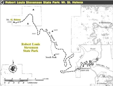
Click Here for Larger Map - PDF
ROBERT LOUIS STEVENSON STATE PARK
At this 5,272-acre park, shade is limited and some areas are hot in summer. No restrooms or camping.
The Mount St. Helena Trail (5.3 miles, 2,100-foot elevation gain) follows a fire road to the summit. Table Rock Trail (2.2 miles, moderate difficulty) winds though forests and chaparral to a scenic overlook. It connects to Palisades Trail (four miles, moderately strenuous), which connects to Oat Hill Mine Road (4.5 miles, moderate). Hikers also can access Oat Hill Mine Road from a trailhead at Highway 29 and Silverado Trail in Calistoga.
Directions: Robert Louis Stevenson State Park is seven miles north of Calistoga on Highway 29. Look for trailheads on both sides of the road at highest part of the highway.
Information for both parks: (707) 942-4575.
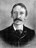
Robert Louis Stevenson State Park is the place where the famous author of Treasure Island and Kidnapped spent his honeymoon in 1880. Although nothing remains of Stevenson’s cabin, the site is identified on the trail to the summit.
The area features rough terrain, with evergreen forests in the canyons on north-facing slopes and chaparral on the south-facing slopes.
There is a five-mile hike to the top of Mt. St. Helena from which one can see much of the San Francisco Bay Area. On good days the top of Mt. Shasta can be seen, 192 miles in the distance.
To protect the park's wildlife and other natural resources, dogs are not permitted in this park.
History:
Before Napa became famous for wine, its economy depended on another natural resource: mining. In the late 19th century, cinnabar (the ore used to make mercury), gold and silver mines dotted the mountainsides of the upper valley. Today, the old wagon roads now form some of the region's best hiking trails.
The mountain was first climbed and named by the Russian traders who settled the West Coast from Alaska as far south as Fort Ross just north of San Francisco. Rising behind the hills of eastern Healdsburg, Mount St. Helena is one of the few remaining mountains in the old Maycamas Mountain chain, a small range that was formed by ancient volcanic activity and runs parallel to the California coastline in the eastern Sonoma County area. Volcanic rocks on and around Mount St. Helena have been dated as 2.4 million years old.
In 1880, Robert Louis Stevenson and his bride, Fanny, honeymooned in an abandoned bunkhouse at the Silverado mine on the slopes of Mount St. Helena. They'd gone there to flee the fogs of San Francisco, which were thought harmful to the writer's sickly and perhaps tubercular lungs.
“The woods sang aloud, and gave largely of their healthful breath,” Stevenson wrote of his first ascent up the mountain. “Gladness seemed to inhabit these upper zones, and we had left indifference behind us in the valley. ... There are days in a life when thus to climb out of the lowlands seems like scaling heaven.”
Or maybe it was just the wine.
Seasons/Climate/Recommended clothing
The best seasons are spring and fall. The winter provides the best vistas, but also the greatest chance of snow and chilling wind.
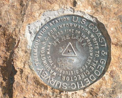
Benchmark Number 2 on top of Mount Saint Helena
The Five Summits
At about 3.1 miles into your hike, the fire road flattens out at a saddle junction. The left-hand road goes to the southwest summit, which is lower than the northeastern summit. The southwest summit is 6.5 miles round-trip from where you started hiking. Depending on conditions, Lassen Peak (just east of north), the High Sierra (east), Snow Mountain (north), Mt. Diablo (southeast), Mt. Tamalpais (south), San Francisco (south) and the Pacific Ocean (west) may also be visible.
The right-hand fork leads to the northeastern summit—the highest point on Mount St. Helena. To reach it, continue on the trail to the north. You'll encounter two more junctions on your way to the northeast peak, but stay on the main trail towards the summit.
After a little less than a mile you'll come to a sharp bend in the road. Continue past this bend for another half-mile. You will pass a radio tower on your right before you reach the antenna-covered crest of Mount St. Helena.
Here, hidden on the southwest side of a large shed, you'll see a plaque commemorating the establishment of the Russian settlement of Fort Ross on the Sonoma Coast, as well as an 1841 Russian ascent of the peak. Amazingly, on clear days you may see the top of Mt. Shasta, 192 miles distant.
Mount St. Helena is the majestic 4,339’ mountain at the heart of Napa County. When viewed from the west, it looks like a woman lying on her side, and in fact it was called "Kana'mota," or "human mountain," by the Wappos. The Wappos considered Mt. St. Helena sacred and did not live on it, but their trails encircled it and the tribe cared for the mountain in part by burning away its underbrush.
Walk through the picnic area towards the Robert Louis Stevenson trailhead marked Monument & Mount St. Helena. You will pass the concrete-slab foundation, which is all that remains of the silver mining town of Silverado. (However, if you see a trailhead marked Table Rock Trail, you’re on the wrong side of Highway 29 and will need to cross to the other side.)
Start on the Mount St. Helena Trail toward the monument. It starts as a graded switchback that takes you towards the Robert Louis Stevenson memorial site. Stevenson, a Scottish essayist, poet and author of fiction, adventure and travel books, won fame with tales like Treasure Island and The Strange Case of Dr. Jekyll and Mr. Hyde. It's said that Mount St. Helena was the basis for Treasure Island's Spyglass Hill.
In late winter and early spring, you may be lucky enough to come across seasonal streams filled with runoff from the spring rains, cascading toward the Napa River as they run alongside portions of the trail.
Travel through the mixed evergreen forest and as you do, watch for fragrant bay laurels, giant madrones and Douglas firs. When you come to a clearing, you'll see a historical monument marking the abandoned miner's shack where Robert Louis Stevenson once spent seven weeks recovering from tuberculosis. He and his new bride, Fanny Osbourne, honeymooned here in 1880 while Stevenson regained his health. He documented their stay in The Silverado Squatters, a pleasant description of their adventures and domestic life.
http://www.bahiker.com/northbayhikes/rlssp.html
The Palisade's trail has been called Calistoga's stairway to heaven. I don't know about that, but it is a freakin awesome hike out to Table Rock.
Having grown up in the area, I was accustomed to seeing these majestic rocky outcroppings up in the hills that hug the northern end of the Napa Valley.
But a few years ago, I went on my first hike out amongst these cliffy wonders. It's a moderate to strenuous hike, about 4.4 miles round trip. If you're in shape, then you'll have no problem! The views of the valley and all the vineyards, especially in fall when they are all glorious shades of orange, red and brown are spectacular and make sure to go to the far right once you arrive on the lava rocks and you will be rewarded with awesome, adrenaline pumping standing-on-the-edge-of-a-cliff delight!
It gets pretty warm up here, even on chilly days (maybe it's all the exertion) so wear layers.
Oh and bring some water and a snack. The last time I went I forgot to bring anything so I was without nourishment and hydration and felt very light headed towards the end of the trek, which was no bueno.
Walking in the Chaparral
To continue on the trail, head through the clearing past the stone monument, watching for the trail's continuation on the right at the far end of the clearing. After a few more yards of shaded switchback, the trail continues as a dry streambed. The terrain is rugged, so watch your footing and be extremely cautious of flash floods here during thunderstorms and during the rainy season. Also, if you're hiking in the morning, note that rattlesnakes frequently sun themselves on the streambed's rocks.
Notice that knobcone pines and chaparral plants such as manzanita and chamise become more common as you scramble up the streambed. Chaparral is a plant community composed of evergreen shrubs and short trees that are adapted to fire and drought-resistant. In fact, chaparral actually needs fire to propagate; a wildfire's extreme heat breaks down the tough coatings on the evergreens' seeds, making them permeable to water and able to grow. Chaparral (from the Spanish "chaparro," or thicket of oak shrubs) grows in areas with poor, rocky soil, hot dry summers, and limited rainfall (12-14 inches/year). As a result, it's found in just five places that have the right combination of warm landmass and cool ocean: California, South Africa, Western Australia, Southern Europe and South America.
After less than half a mile, you'll reach a wide fire road. Carefully note your surroundings before you proceed; as you return this way later, the turn-off into the small streambed you just left would be easy to overlook. You may want to leave a handkerchief or some biodegradable trail marking tape to highlight the trail entrance.
Turn left and walk uphill on the fire road. Note that from here on, the trail is exposed; be sure to protect yourself from the sun. This area features evergreen forests in the canyons lining the north-facing slopes, while chaparral dominates the south-facing slopes.
Find a manzanita or chamise (chaparral). What adaptations to water scarcity can you see? Perhaps you've noticed that the branches, even the terminal branches that hold leaves, are thick, tough and woody. The small leaves may be small and leathery, and, they might hang vertically. All of these adaptations help minimize transpiration, water loss caused by the hot sun. Also because of water scarcity, manzanita living on the mountain's higher slopes will be more shrub-like than tree-like. As you climb, notice that prevailing winds from the west tend to sculpt plants that are higher on the mountain, making them look like they're almost ducking to escape each gust.
Stevenson Memorial Trail
To Stevenson Memorial is 2 miles round trip; to summit of Mt. Saint Helena
is 10 miles round trip with 1,300-foot elevation gain
The best view of the wine country is from the top of 4,343-foot Mt. Saint Helena, reached by a five mile trail that winds through stands of knobcone pine to deliver summit panoramas of not only Napa Valley but the High Sierra and San Francisco Bay as well.
While winter is not the most popular of seasons for touring the wine country, it is the best time for looking down at it from the top of Mt. Saint Helena. Crisp, clear winter days mean breathtaking views from the summit. Local Sierra Club members schedule an annual New Year’s Day hike up the mountain—surely an invigorating way to celebrate the year past and welcome the year ahead.
Most of the summit and broad shoulders of Mt. Saint Helena are protected by Robert Louis Stevenson State Park. Stevenson, best remembered for his imaginative novels, Dr. Jekyll and Mr. Hyde and Treasure Island, honeymooned in a cabin tucked in one of Mt. Saint Helena’s ravines in the summer of 1880.
Quite the world traveler, Stevenson, constantly seeking relief from chronic tuberculosis, globe-trotted from Switzerland to the south of France to Samoa. The native Scot followed his heart to California to marry an American woman, Fanny Osbourne.
Short of money, the newlyweds honeymooned in the abandoned mining camp of Silverado, moving into an old cabin and using hay for a bed. While so encamped, Stevenson filled a diary with local color and later penned an account of his experience, The Silverado Squatters, which introduced him to American readers.
Stevenson flled his notebooks with descriptions of the many colorful Napa Valley denizens—from stage drivers to winemakers—he met. Perhaps the biggest infuence upon Stevenson during his stay on Mt. Saint Helena was the mountain itself; it became the model for Spyglass Hill in his novel Treasure Island.
Today you can take a short (one mile) hike into California literary history by joining the trail leading to the secluded site of the Stevensons’ honeymoon. Wrote Stevenson: “At sunrise, and again later at night, the scent of sweet bays filled the canyon.” A memorial in the form of an open book commemorates the author’s stay on the mountain and marks the site of his cabin.
Travelers interested in learning more about Robert Louis Stevenson and his work should head for the Silverado Museum in St. Helena, located seven miles south of Calistoga. The museum features books, letters, and other memorabilia of Stevenson’s life.
Stevenson Memorial Trail is particularly enjoyable for the first interesting mile as it winds through the forest to the memorial. The next four miles of trail—a well-graded fire road leading to the summit—are frankly a bit monotonous; however, the grand vistas, becoming better and better as you climb, more than compensate.
Directions to trailhead: From downtown Calistoga, at the junction of Highways 128 and 29, head north on the latter road. Highway 29 ascends 8.2 miles to a summit, where you’ll fnd parking at turnouts on both sides of the highway for Robert Louis Stevenson State Park. The trail departs from the west side of the highway. Hint: The not-very-well-signed state park is easy to miss. If you find yourself rapidly descending on Highway 29, you overshot the summit and the state park. Carefully turn around and return to the summit.
The hike: Just above the parking lot is a picnic area. During Stevenson’s day, a stage stop and the Toll House Hotel were located here. The Stevensons came down the hill from their honeymoon cabin to buy provisions.
Signed Stevenson Memorial Trail switchbacks up a shady slope forested with oak, madrone, bay and Douglas fir. A pleasant mile’s walk brings you face-to-face with the granite Stevenson memorial, itself something of a historical curiosity, having been erected by “The Club Women of Napa County” in 1911.
To continue to the peak, scramble up a badly eroded hundred-yard-long stretch of trail to the fire road and turn left. The road soon brings you to a hairpin turn and the first grand view en route. You can admire part of the Napa Valley and surrounding ridges, San Francisco high-rises, as well as two distinct and aptly named nearby peaks: Turk’s Head to the west and Red Hill to the south.
The road continues climbing moderately, but doggedly, up the mountain. Wind-battered, but unbowed, knobcone pine dot the middle slopes of Mt. Saint Helena. Three miles from the trailhead, you’ll pass under some power lines, and another half mile’s travel brings you to a junction with a spur trail leading 0.4 mile to Mt. Saint Helena’s South Peak.
Half-a mile from the summit, the road passes through a forest of sugar pine and Douglas fir, then begins the final climb to the peak. Various transmitters, communication facilities and a fire lookout clutter the summit, but don’t block the view. Vistas include the Sonoma County coast to the west, Santa Rosa due south, San Francisco and the Bay to the southwest, the High Sierra north of Yosemite to the east. On the clearest of days, you might be able to glimpse Mt. Shasta, nearly 200 miles to the northeast.
Using the Valley View, Rocky Ridge, Meadow, Oak Knoll, North Knoll, and Deer trails, this semi-loop route explores most of
Trail Statistics & Information
| Activity Type: | Hiking |
| Nearby City: | Napa |
| Elevation Gain: | Minimal |
| Trail Type: | Loop ~ 3 Miles of Trails |
| Trail Surface: | Dirt Trails & Fire Roads |
| Skill Level: | Easy |
| Duration: | ~ 1 hour |
| Season: | Year-round |
| Open: | Sunrise to Sunset |
| Rules: | No Entrance Fees, No Dogs or Bikes. |
| Local Contacts: | City of Napa Parks and Recreational Department |

Hiking & Biking in Napa’s Robert Louis Stevenson State Park.
Explore the wonders of Napa Valley hiking and biking trails and retrace the route of famed author Robert Louis Stevenson when you head to the Napa Valley park named in his honor. Drive north through Calistoga about 8 miles up Highway 29/Lake County Highway, to reach the Robert Louis Stevenson trails. There are parking areas on both sides of the road.The trail to the left, also known as the North Peak is the longer and the higher of the two Napa Valley trails. This is an 11.2 mile hike round trip. Most of the trail is suggested for hiking only. The trail begins with 0.5 mile of switchback through gentle grade forest before it reaches a monument. This marks the site where Stevenson spent his honeymoon in an abandoned mine building during the summer of 1880. From here you climb more steeply and leave the forest to connect with the fire road. After a short walk you can look down at the patchwork of the Napa Valley vineyards and beyond to Mt. Diablo, and Mt. Tamalpais. The trail continues on past various man made structures and a variety of natural habitats and rock formations. The higher you go the more breath taking the views become.
The trail to the right is called Table Rock or Oak Hill Mine. This trail is 10 miles one way and it is suggested that you park your car at the Lincoln Avenue and Silverado Trail intersection just 0.25 of a mile from out hotel, and then drive another car to the Robert Louis Stevenson park and hike back. This is classified as a moderately strenuous hike that incorporates an abandoned utility road and narrow paths. Part of the trail will also lead you down an old stagecoach road where you can still see the ruts in the road from the years of stagecoach travel. These paths lead you along volcanic cliffs and show evidence of the Napa Valley’s violent geologic past. It is said that this trail is one of the most spectacular trails in the Napa Valley. The elevation is lower than the Robert Louis Stevenson trail, but the close in views of the ever changing vegetation and numerous awe inspiring rock formations make up for the fewer long distance views. After circling the base of the most precipitous cliffs the trail descends to the remnants of Karl Holm’s homestead, where the trails end at the historic Oak Hill Mine.
For the stronger at heart you can start the hike from the trail head at the Silverado Trail intersection. This route climbs from 400 feet in elevation to more than 2,200 feet very rapidly.