Bothe Napa Valley State Park |
 |
- Location - Directions
- The park is located 5 miles north of St. Helena and 4 miles south of Calistoga on Highway 29/128.
- Latitude/Longitude: 38.5376 / -122.5788
- Camping, picnicking, swimming, and hiking trails
- Dogs are restricted to the camp and picnic areas and must be leashed.
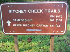
Hiking: there are well over 10 miles of trail.
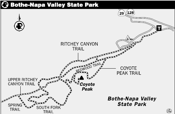
- History Trail (1.2 miles) - from the picnic area the trail passes the Pioneer Cemetery, after which there is a three-way junction. The middle path of the junction heads up sharply through a mixed forest. From the peak of the trail, the hike goes down to Mill Creek and passes a stone dam, after which it reaches the Grist Mill. The trails in this park do not loop, so hikers just retrace their original path to get back.
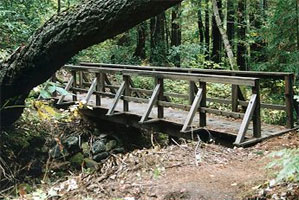
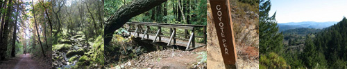
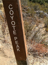
- Coyote Peak Trail (1.5 miles) - starting from Ritchey Creek, this hike climbs up to 1170 feet to a point from which hikers can oversee Napa Valley
- Ritchey Canyon Trail (3.9 miles) - a hike along a stream, which gets harder as the hikers move further when the trail becomes more difficult and leads into a small canyon. Along the Richey Canyon Trail are other smaller hikes like Redwood Trail (1 mile) and The South Fork Trail (.9 mile)
- For easy walks, try the Petrified Forest Loop. The trail is a quarter-mile long and can be walked as many times as is comfortable for the hikers. The hike is in the developed part of the park
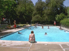
Swimming: Memorial Day weekend through mid-June, then daily through Labor Day, from 12- 6 p.m. There is an additional fee for the use of the swimming pool, to be paid at the park entrance.
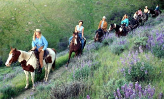
Horseback riding: horseback ride during the spring, summer, or fall. Reservations for horseback rides can be made through Triple Creek Horse Outfit by calling (707) 933-1600.
Picnics: The large picnic grounds are located in the day use area, and are even available for group events and getaways. A covered area for group use contains picnic tables, a sink and an electrical outlet with a horseshoe pit and wheelchair-accessible restroom nearby.
Interpretive programs: offered throughout the year. Special programs can sometimes be arranged for groups by calling the park in advance.
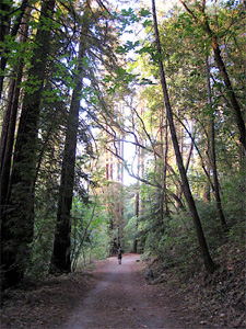
Escape Napa's hustle and bustle via a little slice of open space filled with some of the easternmost coastal redwood trees in the state. Located just north of St. Helena on Napa Valley's busy Highway 29, Bothe-Napa Valley State Park features a hiking loop with lots of variety and rewarding views.
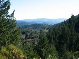
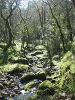
Start the hike alongside Ritchey Creek, where redwood groves and large maple trees with autumn-gold leaves shade the way. The path eventually veers and rises steadily; near the summit, the trees give way and the trail becomes exposed. The best views are from just below Coyote Peak, where a break in the forest creates a wide-angle panorama of St. Helena and the Vaca Mountain Range.
Complete the loop by descending the south side of the peak, which links up again with the Ritchey Canyon Trail. After your ramble, continue the redwoods theme with wine-tasting in one of Napa's few outdoor 'tasting rooms.' About 2 miles north of Bothe-Napa Valley State Park is blink-and-you'll-miss-it Diamond Mountain Road where you'll find Reverie Vineyard and Winery, a 40-acre winery on the side of a mountain. Reverie prefers appointment-tastings, but its personal approach to winemaking and tours merits the effort. Sit and sip under the redwoods—the perfect way to end a Napa day.
 |
 |
| |
|
 |
 |
| |
|
 |
 |
| |
|
 |
 |
Note: WATER CONSERVATION measures are in place at the park.
Water Conservation continues to be in place at Bothe-Napa Valley State Park. Website information will be updated if the groundwater supply is not able to produce enough to keep up with day-use picnicking and camping water demand. (Updated July 28, 2010)
- Water to fill R.V. tanks, has been shut off at the park's filling station.
- Pay showers are available.
- The swimming pool is open for the summer season.
- Campground reservations can be made by contacting Reserve America.
Located in the heart of the beautiful Napa Valley wine country, the Park offers camping, picnicking, swimming, and hiking trails that go through stands of coastal redwoods as well as forests of Douglas-fir, tanoak, and madrone.
Daytime visitors can enjoy a leisurely stroll in Ritchey Canyon on the Redwood Trail to view the delicate ferns and listen to the water splashing down the rocky creekbed. Bring your wine and cheese and picnic under the towering Douglas Firs.
On hot summer days, grab a swimsuit and towel and come enjoy a dip in the park's swimming pool open on weekends, beginning on Memorial Day weekend through mid-June, then daily through Labor Day, from 12- 6 p.m. There is an additional fee for the use of the swimming pool, to be paid at the park entrance.
The large picnic grounds are located in the day use area, and are even available for group events and getaways. A covered area for group use contains picnic tables, a sink and an electrical outlet with a horseshoe pit and wheelchair-accessible restroom nearby.
Whether you visit the back country on a several hour hike or take a mere stroll along the creekbed, you will enjoy a close-up look at all the natural beauty that the park has to offer. There are well over 10 miles of trail for your indulgence.
Seasons/Climate Recommended Clothing
The park exhibits more seasonal changes than most Californians experience. Hot, dry summers change to mild, wet winters; in between, in spring and fall, the park and its surrounding area are probably at their finest.
Summer temperatures may reach 105 degrees Fahrenheit, but nights are usually cool. In the fall, when daytime temperatures are more pleasant, the leaves begin to turn, creating a dramatic and colorful display.
Temperatures don't often go below freezing and snow is infrequent, but nearly 45 inches of rain are apt to fall during a single winter - between December and March.
Most of the park is rugged, with elevations ranging from 300 to 2,000 feet. You will notice a pattern in the vegetation: the forests are on the north-facing slopes and in canyons, while south-facing slopes tend to be brushy; redwoods grow only near creeks or springs.
Plant life hides much of the park's geology, which is principally volcanic, but you can see a reminder of the area's violent geologic past in the volcanic ash cliffs of upper Ritchey Canyon.
The park is home to raccoons, gray squirrels, deer, foxes, bobcats, and coyotes to name a few, but they are sometimes difficult to spot because of their nocturnal habits and the heavy forest cover.
Dogs are restricted to the camp and picnic areas and must be leashed. They are not permitted on the trails or in the pool area. Dogs may not be left unattended and must be inside a vehicle or tent at night.
Several species of birds can be easily detected though, including the six kinds of woodpecker that inhabit the park. The spectacular crow-sized pileated woodpecker is one of them. On a more rare occasion a spotted owl can be found, perched high in a redwood tree.
Located by the entrance to the park is the Visitor Center. The Visitor Center and entrance station are open intermittently when staffing is available. Brochures (hiking maps) are also available by mail.
Next to the park's visitor center is the Native American Garden which displays some of the plants important to the first people of this area. Today, many of the same plants are used by the Wappo people. A guide for the garden is available by mail or in the visitor center to broaden one's understanding of the first people.
Near the day use/picnic area is the Pioneer Cemetery, resting-place of some of the original settlers of the Napa Valley. The cemetery is an interesting place to visit while on a day hike, and is currently under restoration to return it to its original, mid-1800's appearance.
Interpretive programs are offered throughout the year. Special programs can sometimes be arranged for groups by calling the park in advance.
Trail Statistics & Information
Bothe-Napa Valley State Park is located 5 miles north of St. Helena on Hwy. 29. The Coyote Peak loop trail is about 4.5 miles. Park at the trailhead, on the right of the road just past the visitor center. Start hiking on the Ritchey Canyon Trail. Follow this along Ritchey Creek until you reach Redwood Trail. Follow this to the Coyote Peak Trail. A signed spur trail goes to the summit. After taking the spur trail, continue on the Coyote Peak Trail to the South Fork Trail and go right. Cross Ritchey Creek, and turn right on Redwood Trail. Cross the creek again to Ritchey Canyon Trail and continue all the way back to the parking lot. Dog are allowed in the park, but not on the trails.