

If someone not familiar with disc golf saw the course at Skyline Park without players using it, they might think the 18 steel structures sticking out of the ground were plant holders, or maybe small radio antennas.
They actually are targets for flying discs, known commercially as Frisbees. Each one has inner and outer rings of hanging chains that stop the horizontal flight of a disc and, if hit squarely, drops it into the basket — like a golf ball into the cup. The inner chains also keep the disc from hitting the basket post and getting damaged.
The Skyline Park course is hillier and tighter than most disc golf courses, said Napa resident Marvin Paul, who led a small group that built it 14 years ago. Paul, who has been playing disc golf for 30 of his 47 years, takes a lot of pride in his creation.
He was playing on it Monday, despite a weekend of rain that left most of Skyline Park too soggy for hiking.
“The beautiful thing about the course is that it drains really well,” Paul said. “The trail getting out there can get a bit squishy and muddy, but the course is relatively dry. We’ve had some issues with the tee boxes, even though we have rubber tees. The soil doesn’t hold the dirt back, so it’s a constant battle to keep those dry during wet season.”
Disc golf has been around since the 1970s, when some might have confused it with disco.
The first permanent course was built in La Canada, next to Pasadena.
“In Frisbee’s heyday, from 1974 to 1982, they held the world championships at the Rose Bowl,” said Paul, a native of Pasadena neighbor Saugus. “They were multi-event competitions, with everything from freestyle to distance to run-catch-and-throw timed things. Disc golf was one of many events there, probably the most popular one, with Ultimate (disc football) being a fair second.”
One event, Distance, measures how long and far a flying disc can stay airborne. Paul said the current world record of 820 feet, or 17 seconds, was set eight years ago.
Napa Disc Club will have its annual Vintage Cup tournament Feb. 26-27, with skill competitions between rounds. There are different skill levels, and for the entry fee participants also receive a gift packet that includes a commemorative tournament T-shirt and disc.
Paul recommends that players have more than one disc, if not toting full sets of disc like ball golfers do with clubs.
“You want to have back-up discs in case you lose one in the bushes, because you have only three minutes to find it. I went from carrying around one set of 12 discs to carrying two sets.”
For those who just want to play, Paul said the Napa Disc Club will begin playing Thursday evenings at Skyline after the daylight-savings time change in March.
“The park stays open longer for disc golfers those nights, and we have a handicapping system so everyone’s competitive,” he said, adding that the players put money in a pot and battle for the combined sum.
Paul manages the course and organizes work parties to maintain it. The club has about 20 members, most in their mid-20s to mid-30s and a few in their 60s. He said one works at Silverado Resort part-time and can play ball golf there for free, but likes disc golf more.
The 17-acre Skyline disc golf course is about a third the length of a typical ball golf course.
“We measure holes in feet instead of yards,” said Paul, who estimates Skyline’s course to be about 5,500 feet long. “It’s a relatively small space, but it’s got a lot of hills. Several holes are only 250 feet or so, but when you’re going uphill, it’s like you’re playing an extra 100 feet. Some greens are tough to get to, and we have two to four different pin positions to make them shorter or longer holes. As disc courses go, ours is shorter and more technical. It’s all about making birdies.
“A lot of courses are flat and shots become muscle memory. Here, you’re lucky if you can use the same putting stance twice. Even the flattest greens are slightly sloped, so precarious stances are commonplace. If you doink the basket, the disc might go rolling 100 feet backward. You have to consider laying up because you might have a cliff behind the basket. On a couple of holes, you could be within 30 feet and not have an easy putt because there’s a big bushy tree in the way. In tournaments, you can’t make a forward-motion follow-through if you’re within 30 feet, so you have to have a straddle stance.”
There are also disc golf courses in Vacaville, Novato, Petaluma and Berkeley, but Paul would like to see more people using the course at Skyline Park.
“Our course is one of best-kept secrets in disc golf. Not a lot of people know about it, even though it’s the second-busiest activity at the park next to hiking.”
For more information about the Napa Disc Club or the Skyline Park course, call Paul at 224-2416.
Overview of Park :
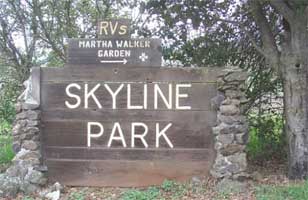
Skyline Wilderness Park is a one-of-a kind public park and an invaluable resource for the Napa County community.
The 850 acres which make up Skyline Park lie in unincorporated Napa County just outside the southeast edge of the City of Napa. The lands are spectacular. Topography ranges from 100 to 1650 feet in elevation and provides views to Mount St. Helena to the north, Mount Diablo to the southeast, to San Pablo and San Francisco Bay to the south, Mount Tamalpais to the west, and Mount Veeder to the northwest.
Though the park is best known for its unparalleled recreational value, with trail systems that have been in use since the middle of the 19th century, it is exceptional in many ways. Animal habitat is especially diverse. Water resource conservation value is great. The park’s location provides critical linkage to the developing network of regional trail systems that run throughout the Bay area. Skyline Park is the only public outdoor space in the County that is large enough to host recreational activities and community events that require great expanses of outdoor space.
The park is located on land owned by the State of California. In 1979 the State determined the land was no longer needed for State purposes and initiated the process of selling it as surplus property. Thanks to the forward thinking of a group of local citizens, it was not sold but instead was leased by the State to the County of Napa in 1980. The lease stipulated that the property would be developed and used as a public park consistent with a General Development Plan approved at that time or as subsequently amended.
The volunteer group ncorporated as the non-profit Skyline Park Citizens’ Association (SPCA) and contracted to manage the development and operations of the park as a concessionaire on behalf of the County and the community.
Natural Park Features
FLORA AND FAUNA
Plants: The dominant plant community at Skyline Park is oak woodlands, including valley oak, coast live oak, blue oak, black oak, California bay and madrone.
- The buckeye trail is lined with its namesake, the California buckeye.
- The northern flat portion of the park is primarily open grasslands consisting of mostly of non-native annual grasses and a variety of native and non-native forbes.
- Patches of open grasslands are also found at various locations elsewhere in the park.
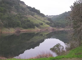
- Chaparral is found primarily along the eastern edge of the park, and includes such characteristic plants as chamise, manzanita, sticky monkey flower and coyote bush. Riparian vegetation extends along the length of the creek feeding into Lake Marie at the southeast end of the park, through the length of the park into Lake Camille
and eventually into Tulocay Creek northwest of the park. - The riparian vegetation includes white alder, California bay, willow and big leaf Maple. Areas of cattail, bulrush and related freshwater marsh vegetation located along the banks of Lake Marie and in a constructed wetland next to the Martha Walker Native Habitat Garden.
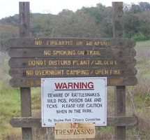
Animals: The park is home to many animal species, with raptors, deer and large flocks of non-native turkey among the most noticeable. Sightings of mountain lion, peregrine falcon, rattlesnakes, coyote and bobcat are often reported in to the information kiosk.
Park Facilities:
ARCHERY RANGE
- Hospitality area: There is a small gathering facility at the southwest corner of the range.
- 25 acre range: The fenced range consists of open, rolling terrain to the east of the main entrance with 42 targets, operated by Silverado Archers Inc.(NFAA).
- The range is charted with 3 separate NFAA marked yardage ranges, each range having14 permanent targets as well as an area for 14 unmarked distance targets utilizing McKenzie 3-D’s. The club host a number of tournaments each year for target archers and hunters
- Camping Tent: There are 20 rustic sites near the social hall.
- Equestrian: There are 10 sites located in the southwest of the developed part of the park, near the horse arena. Each site has a picnic table and water and accommodates two horses and two rigs.
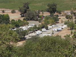
- Recreational vehicle (RV) park: Located south of the entry, there are 39 sites plus an overflow area. The park includes the following: water/electrical hookup at each space; restrooms and showers (two each), a dump station, parking for an additional vehicle adjacent to each space, and a small, fenced dog exercise area
- DISC GOLF: 18 hole range on approximately 15 acres: There is a short, technical course on rolling, fairly open land that can be played in two hours. Alternately, it can be played as either the front nine or the back nine.
- EQUESTRIAN FACILITIES
Arena for day and event use (for both equestrian and other uses). Regularly scheduled schooling shows (western, trail, gymkhana and English), as well as 4-H and other youth shows are held in the sand arena. The arena is otherwise available for training. A separate covered arena has been approved by the county and state, but has not yet been constructed. - Exercise ring: There is a small ring for warming up horses in a small area near the main arena.
- Trail trial course
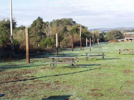
- OUTDOOR EVENT SPACE/ PICNIC AREAS
- Individual, family, large group picnic facilities (One large group area, three wilderness areas)
- Cook shack/BBQ
- Refreshment bar
- PARKING
- Striped, paved day use parking (58 spaces) and additional informal parking at the social hall
- Horse trailer parking area
- SOCIAL HALL
- Large gathering space (2,275 square feet): Located south of the park entrance, the social hall includes a conference room, event kitchen and serving station counter. There is a small outdoor entertaining area on the south side of the building. Restrooms and informal parking are adjacent.
- Large gathering space (2,275 square feet): Located south of the park entrance, the social hall includes a conference room, event kitchen and serving station counter. There is a small outdoor entertaining area on the south side of the building. Restrooms and informal parking are adjacent.
- TRAIL SYSTEM
- 20+ miles of unpaved trail: Ranging from rocky single track to smooth fire road, with varied levels of difficulty and access for hikers, cyclists and equestrians, the trail system is the pride and joy, as well as the central focus, of the park.
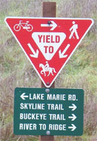
- Regional trail systems connections: The Park is host to a section of the Bay Area Ridge Trail, which is planned to eventually connect south to American Canyon, east to Solano County, and north to northern Napa Valley. The park also connects to the San Francisco Bay Trail and the Napa River Trail
via the River to Ridge Trail at the southwest edge of the park.
History of Park:
In the late 1970’s the State of California was prepared to sell off as surplus property approximately 850 acres of land adjacent to the Napa State Hospital in Napa County. Theland contained significant stretches of undisturbed wilderness areas and had been informally used for hiking and other outdoor recreational purposes by locals for years.
At the time, the County of Napa had neither a Park and Open Space District, nor a Park and Recreation Department. Due to a lack of resources and administrative capability, county officials showed little interest in acquiring the land for preservation and recreational use.
Fortunately, State Senator John Dunlap and many members of the community, recognized the opportunity at hand for the citizens of Napa County and refused to let it pass. They assembled a citizens group of open-space advocates who worked with the Board of Supervisors and County staff to devise a plan to have a non-profit organization operate the
park. Under this plan, the organization would be responsible for normal park operations and maintenance at no cost to the County. The State agreed. The group became an independent, non-profit organization known as the Skyline Park Citizens’ Association (SPCA.)
In 1979, anticipating leasing the parkland from the State, the County signed a concessionaire agreement with the SPCA, delegating responsibility to them to operate a public park on the land. On January 9, 1980, the State officially leased the land to the County of Napa for a term of 50 years, to begin February 20, 1980, for a fee of $100.00 per year.
This 850 acres came to be known as Skyline Wilderness Park. The lease agreement included informally drawn boundaries on site maps, with a stipulation that a more formal legal description of the property would be made at a future date. To date, a formal legal description has not been prepared. Skyline Park is one of the few, if not the only, park in California and possibly nationally which is operated entirely by volunteers under this type of public-private
partnership arrangement.
With some initial bond funds from the County, local volunteers, under the leadership of the SPCA, spent the next three years transforming the Skyline property into the public park they had promised a somewhat skeptical State of California that they would make. They installed fencing, a parking lot and an information kiosk. They forged trails. “ I remember riding my horse through the brush, finding the best route,” says one equestrian who participated in the early work. “I remember my husband and I and our friends tramping out the trails with our feet,” says another. “We had big work-parties and whole families came -- the kids helped too.” The park couldn’t open without restrooms, so chemical toilets were installed.
On April 15, 1983 Skyline Wilderness Park opened its doors for the first time. The community was welcomed with a huge open house on May 14th of that year.
The SPCA, and a host of volunteer community members too numerous to list, spent the next 15 years developing Skyline into a self-sufficient public park. Mountain bikers became official park users and volunteers in 1984. That same year, a dozen telescopes were set up in spring and fall to give the community a chance to gaze at the stars. A trail riding company came in and ran guided horse-back rides on the trails. Additional trails were built. A formal picnic area was built using tables donated by Bothe-Napa State Park. Formal equestrian facilities were added. A mobile home was set on the property to accommodate a live-in park ranger.
Cattle grazed the land through a rental agreement for many years prior to the park being leased to the County. The cows stayed on in the park for several years after the park opened, providing a sure source of income. Eventually, however, they wore out their welcome, tearing up trail sign posts and getting into other bovine mischief, and the grazing
agreement was scrapped. Plans were then hatched to create a recreational vehicle campground to replace the much needed operating funds previously provided by grazing fees.
Throughout the 1980’s, SPCA continued to develop the park. An archery club joined the mix, carving out an exciting range for their members and the public. Eagle Cycling Club’s involvement grew, and they donated bicycle racks and a bicycle for trail patrol. A tool shed and pump house were built and infrastructure was expanded in the developed areas. A small barn donated to the park was installed and expanded to become the Social Hall that exists today. In 1985 a haunted house grossed $5100.00 for park operations. Feral pigs loved the park as much as the local community and became the nuisance that they continue to be today.
The 1990’s brought more people to enjoy the park and more organizations to help program and operate it. The Napa County branch of the California Native Plant Society (CNPS) was one of these organizations. They sponsored re-vegetation and education programs and developed the Martha Walker Native Habitat Garden. Today CNPS grows local native plants for use in the park and elsewhere in the valley, and holds regular sales to the public. They created a foundation to support their work in the park. Concurrently, SPCA opened a tent campground, and two new trails, including the Rim Rock trail to the summit of Sugarloaf Peak.
It was during this period that the park began to be known as an outstanding venue for large events. Among them were the Napa Valley Music Festival, the California State Horseman’s Trail Trials, the Napa Sheriff’s Posse Invitational and World Cup Mountain Bike Races. In 1998, a disc golf club began working with the park to set up a range. The range now attracts players from all over the West. By August 6th of 1998, when ground was broken for a segment of the Bay Area Ridge Trail leading from the park onto adjacent private land, the park had achieved its vision of being a self-supporting park. Also by the end of that decade, the invasive plant species, star thistle, was edging out the feral pig as the top nuisance in the park, and signs of mountain lions were causing concern for the SPCA, who worried about
park users’ safety.
The turn of the 21st century brought a website and increasingly diverse use of the park’s facilities. The SPCA welcomed the public, learning what worked and what didn’t as they went. School groups began to make more organized use of the park’s amenities, as the Boy and Girl Scouts had for years. The popularity of the trails began to present a problem for the limited, mostly volunteer, trail maintenance resources of the SPCA. A long-term solution for this problem has yet to be found. The park leadership also pressed for acquisition of the adjacent Vallejo Lakes property, an effort that continues today.
Twenty-six years have passed since Skyline Wilderness Park opened its gates. The SPCA held their planning and problem solving meetings in local schools, banks, each other’s homes, and at the Valley Bible Chapel, until they finally came to rest in the business office in the Social Hall. During these 26 years, a passionately committed group of outdoor-loving volunteers has turned 850 acres of open space into an oasis of nature, healthy activity and
fresh air, for which the people of Napa County will be forever grateful.
